Kham is one of the three traditional provinces of Tibet, with the two others being Amdo (in the northeast) and U-Tsang (in central Tibet). The Wylie transliteration of Kham´s Tibetian name is Khams.
Kham is a rugged but also fertile region, where six valleys and four rivers converge. It has plenty of dense forest and grassy plains, and is characterized by mountain ridges and gorges running from northwest to southeast. Examples of notable rivers that flows through Kham are the Mekong, the Yangtze, and the Salween.
Today, the area of the traditional province of Kham covers land in both modern-day Tibet and modern-day China. Most of it is in the Tibet Autonomous Region and in the Sichuan province of Southwest China, and only smaller portions are located in the provinces Qinghai, Gansu and Yunnan.
In 1950, the People´s Liberation Army invaded western Kham. Eventually, eastern Kham was forcefully merged into Sichuan in 1955, and western Kham was subsequently merged into the Tibet Autonomous Region in 1965. The Yangtze River forms the border between Sichuan and the Tibet Autonomous Region. Under the modern administrative division of China, Kham is divided into 50 counties, of which 25 are in the Tibet Autonomous Region.
The Khampas
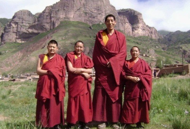
The Khampas – the people of Kham – were historically described as tall warriors renowned for their marksmanship and horsemanship, and for having at least partly Mongolian ancestry and heritage. Even today, there are notable physical differences between the majority population in the Lhasa region and the majority population in Kham. The average height for am adult Khampa man is circa 180 centimeters. There are also many differences in traditional beliefs and habits between the two groups.
The majority language in Kham is Khams Tibetan, but at least one-third of the residents speak languages belonging to the Qiangic language family.
Early history of Kham
The 7th and 8th century AD
The Pugyal Dynasty of the Tibetan Empire sent troops from Lhasa to take control of the region that would eventually become recognized as eastern Tibet or Do Kham. Kham signifies frontier, while Do denotes the convergence of rivers. Back then, Kham was also known as Chusi Gangdruk, which means The Four Rivers & The Six Ranges. King Songsten Gampo, who reigned Tibet 629-649 AD, ordered the creation of twelve “border-taming” Buddhist temples in Kham. Eventually, both Nyingma Buddhist and Bon Buddhist monasteries were established here, and carved Buddhist art from the 8th century has survived in Kham.
The Tibetian Empire crumbles
The Tibetian Empire began contracting in the mid-800s, and eventually Tibet separated into independent kingdoms. The people living in Kham went back to being more independent. Invasion attempts were made, but the Khampas resisted with fervor.
For many centuries, Kham was not controlled by any single ruler. Instead, it was a loose patchwork of a kingdoms, tribes and chiefdoms.
Invasion
In 1639, Mongolian troops invaded Kham and executed Doyo Dorje, the King of Beri in Kham. He was a practitioner of the Bön religion, while the Mongolian troops were led by Prince Güshi Khan who supported the Dalai Lama and the Gelug school of Tibetan Buddhism. (It was Prince Khan´s assistance that enabled the 5th Dalai Lama to establish political control over Tibet.)
Over the comming years, many Gelug monasteries were established in Kham. In 1677, the 5th Dalai Lama determined the Sino-Tibetan border location, reunified the Koshut Khanate and more firmly established Kham as a part of Tibet.